The weather of 2017 at the marine surface over the EUMETNET area can be viewed above.

The weather of 2017 at the marine surface over the EUMETNET area can be viewed above.
utoPollen programme participants come from 25 institutes and associations from 22 countries that are either EUMETNET members or cooperating third parties. An extensive list of participants, as well as a list of publications and links to projects and networks across Europe, can be found on the AutoPollen website along with relevant data.Participants and Collaborations
Furthermore, the AutoPollen programme collaborates with several European-level projects and organisations, including: Horizon Europe Project SYLVA (A SYstem for ReaL-Time ObserVation of Aeroallergens), Copernicus Atmospheric Monitoring Services (CAMS), the COST Action ADOPT (New Approaches in Detection of Pathogens and Aeroallergens – CA18226), EURAMET on the BioAirMet project, and Working Group 39 of the European Normalisation Committee (CEN - Technical Committee 264).
Research and Development enhances the evolution of our national and international observing networks. For example, we are currently working with several GNSS analysis centres to understand the value of additional products derived from GNSS signals. We also planning to collaborate to the NAWDIC campaign in 2026 to better understand and optimise our marine monitoring network to better forecast high-impact hazards from extra-tropical storms. Research and Development
We work closely with data users and monitoring systems providers to research and define future weather observation requirements. This ensures that our networks evolve to meet ever-changing demands for weather observations. By funding, designing and coordinating research and development, we evaluate the impact of changes to our monitoring network or trials of emerging capabilities on downstream user applications.
The benchmark is a key deliverable of the EUMETNET Post-Processing module, designed to provide high-quality benchmark datasets and infrastructures for comparing the various methods used to post-process forecasts in National Meteorological Services. The benchmark is composed of two components: gridded post-processing, which requires gridded observations, forecasts, and reforecasts; and station-based post-processing, which requires station observations and forecasts and reforecasts at the nearest point. For more information on the benchmark activities of the PP module, you can visit our website: Technical details and relevant codes are developed on GitHub:Post-Processing Benchmark
https://eupp-benchmark.github.io
https://github.com/orgs/EUPP-benchmark
Base dataset – Low-resolution gridded data The benchmark dataset consists of 47 fields, with at least seven requiring post-processing. It includes daily forecasts at midnight, which feature ensemble, control, and high-resolution ECMWF runs, as well as reforecasts twice a week and hourly analysis data. The training set covers 2017 and 2018, while the test set is for 2019. The total size of the gridded benchmark is about 6 terabytes (TB), with the training set being 4.3 TB and the test set 1.6 TB. This dataset provides a solid basis for evaluating and comparing different post-processing methods used by National Meteorological Services. More details about the base dataset can be found at https://eupp-benchmark.github.io/EUPPBench-doc/files/base_datasets.html. EUPPBench datasets The EUPPBench datasets also include station data all over the selected domain and ECMWF forecasts and reforecasts from the nearest grid point. An example of deterministic IFS forecast for 100m u wind and the corresponding gridded observations in the EUPPBench dataset.Benchmark Datasets
The benchmark base dataset is a low-resolution gridded dataset that covers the European area from 36 to 67° in latitude and from -6 to 17° of longitude, with grid spacing of 0.25°x0.25°.
In addition to the base dataset, specific datasets for statistical and machine learning over a smaller domain have been designed. The EUPPBench datasets are available over a smaller area within Europe, stored in Zarr format for easy access. The forecasts and observations datasets are already paired together, providing analysis-ready data for post-processing benchmarking purposes. 
With these datasets, the first benchmark of several post-processing methods was conducted and published in Earth System Science Data (ESSD). More details on the EUPPBench datasets and this first benchmark can be found at https://essd.copernicus.org/articles/15/2635/2023/.
Bojinski S, Blaauboer D, Calbet X, de Coning E, Debie F, Montmerle T, Nietosvaara V, Norman K, Banon L, Schmid F, Strelec Mahovic N, Wapler K, 2023: Review: Towards Nowcasting in Europe in 2030, Meteorological Applications, https://doi.org/10.1002/met.2124 Publications
Special Issue in Meteorologische Zeitschrift, Development and Application of Seamless Prediction Systems
Part I: https://www.schweizerbart.de/papers/metz/list/29#issue3
Part II: https://www.schweizerbart.de/papers/metz/list/29#issue4
Sivle A, Agersten S, Schmid F, Simon A, 2022: Use and perception of weather forecast information across Europe, Meteorological Applications, https://doi.org/10.1002/met.2053
Schmid F, Wang Y, Harou A, 2019: Nowcasting Guidelines - A summary, WMO Bulletin 68(2), 63-68; https://library.wmo.int/viewer/38575/?offset=#page=3&viewer=picture&o=bookmarks&n=0&q=
WMO in cooperation with E-NWC, 2017: Guidelines for Nowcasting Techniques, WMO Nr. 1198,
https://library.wmo.int/records/item/55666-guidelines-for-nowcasting-techniques
ENC 2014: European Nowcasting Conferences (ENC)
http://www.zamg.ac.at/ENC2014/
ENC 2017: https://www.dwd.de/EN/specialusers/research_education/seminar/2017/enc/enc_en.html
Conference paper: DOI: 10.1127/metz/2017/0870
ENC 2019:
Conference paper: DOI: 10.1127/metz/2019/0983
ENC 2022:
https://eumetcal.eu/en/ui#/page/ENC2022%20
Conference paper: DOI: 10.1127/metz/2022/1156
Several international meteorological organisations collaborated on a research project examining nowcasting capabilities and Early Warning Systems across different global regions. Working groups from the World Meteorological Organization's World Weather Research Programme and EUMETNET's Nowcasting module led this initiative. More details can be found here: https://wwrp-nowcastingcapabilities.com/ Cooperation with WMO
38 European National Meteorological Services contribute to the consistent visualisation of weather awareness information, thereby ensuring coherent interpretation of multi-hazard early warnings throughout Europe.METEOALARM Website
Visit the MeteoAlarm Website for the latest weather-related awareness situation and further information. 
The MeteoAlarm Feeds provide a thorough summary of active multi-hazard early warnings, aggregated according to each NMS contributing to MeteoAlarm. Subscriptions to Atom and RSS Feeds are easy to access. Information necessary for redistributing warnings from the contributing NMSs is accessible in the Redistribution Hub on the MeteoAlarm Website. It includes the MeteoAlarm Redistribution Guide, the MeteoAlarm Common Alerting Protocol (CAP) Profile, the Service Level Agreements (SLAs), and other relevant documentation. METEOALARM Feeds
In the RODEO Project, new Application Programming Interfaces (APIs) are being developed for MeteoAlarm. These APIs enable access to multi-hazard early warnings through cross-border queries and bulk downloads for archived warnings. The goal is to improve the sharing and accessibility of warnings by integrating these capabilities into MeteoAlarm, including Near-Real-Time, Archived Warning, and Storm Name APIs. METEOALARM APIs
“Early Warnings for All is a groundbreaking initiative to ensure that everyone on Earth is protected from hazardous weather, water, or climate events through life-saving early warning systems by the end of 2027." The EMMA Programme supports these activities within the WMO Regional Association VI (Europe) by providing life-saving multi-hazard early warnings to the public across 38 European countries, with the potential to extend its capacities to other countries as the initiative progresses. Early Warnings for All
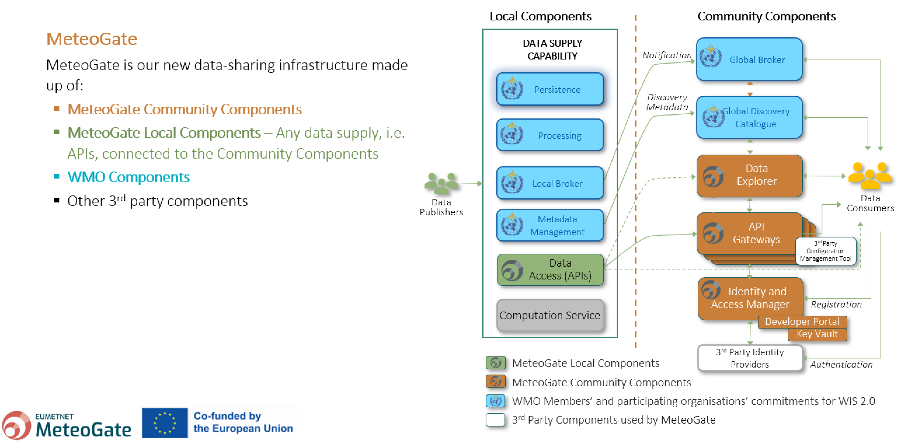
1- MeteoGate will enable the sharing of hydrological and meteorological data holdings both within the European Meteorological Infrastructure (EMI) and between the EMI and external stakeholders (global WMO community, public and private sector bodies, research institutions, citizens, etc.). The MeteoGate System will be part of the WMO Information System and will implement the WIS 2.0 principles. 2- The initial scope of MeteoGate includes sharing the following categories of data: Core Data (WMO Unified Data Policy), Meteorological High-Value Data (EU Regulation 2019/1024), and Data for Official Duty1. The MeteoGate System will be extensible so that additional functions can be incorporated as user requirements emerge. 3- MeteoGate will enable data sharing in a manner that is compliant with national and international legislation, regulation, and policy commonly applicable to the EMI, with priority given to obligatory requirements. 4- MeteoGate will support the data-sharing policies commonly used within the EMI, including but not limited to free and open data exchange. 5- MeteoGate will neither affect ownership of shared data holdings nor impose additional conditions on data sharing. 6- The ownership, origin and license / usage terms of data holdings shared via MeteoGate will be visible to all stakeholders. 7- Policies and technical standards ensuring interoperability and consistency of operation among components of the MeteoGate will be mutually agreed and maintained by European NMHSs, EUMETSAT and ECMWF under the auspices of EUMETNET. 8- MeteoGate will be comprised of multiple components (e.g. data sharing platforms and systems), each owned and operated by constituents of the EMI and conforming with the mutually agreed policies and technical standards. Providers of MeteoGate components are encouraged to develop and/or operate them in a manner that supports the community. MeteoGate components may form part of national data-sharing infrastructures and vice versa. 9- MeteoGate will build upon existing data-sharing infrastructures, incorporating them when they conform to the mutually agreed policies and standards. MeteoGate will undergo continuous development as needs arise in the EMI. 10- MeteoGate will provide access to data holdings in-situ where local capability exists to do so. Moving data to a remote system only to support data sharing should be avoided. 11- MeteoGate will have a single catalogue describing all its data holdings and will provide mechanisms to enable users to search for the data they need. MeteoGate will make metadata contribution to the catalogue easy; aiming to avoid duplicate effort where data providers contribute to multiple data sharing initiatives. MeteoGate Principles
MeteoGate Community components are needed to deliver shared capabilities, e.g. a data catalogue or access management. They will be established and operated by EUMETNET or its members and useable by data publishers and consumers inside and outside the hydro-meteorological community. 1- A shared Data Catalogue defining and describing data assets and data collections, indexed, linked, and searchable to support data discovery and usage. 2- A Message Broker with a subscription service for notifications about the updates to both discovery metadata and the data. 3- Identity & Access management to control user and system access to platforms and platform services. 4- API management providing the interface between data consumers and underlying data stores, enabling managed access and usage of data and data products. 5- An Insights service reporting on data discovery and publication transactions for Data Publishers to derive management information. MeteoGate Community Components
Why do we need a phenological database? The PEP725 database is regularly updated with new data provided by EUMETNET members and their partners. The National Meteorological Service of Austria (GeoSphere Austria) manages the PEP725 database, which is freely available for education and research. Downloads and requests for data, as well as the number of peer-reviewed publications based on the PEP725 dataset, have been increasing steadily. Who’s in charge? Pan-European Phenological Database (PEP725)
Phenology – the timing of natural events in the life cycles of animals and plants – is perhaps the simplest process to track changes in the ecology of species in response to climate change (IPCC 2007). In most European countries, different governmental and non-governmental organisations have routinely carried out phenological observations for more than 50 years following different observation guidelines. Having the phenological data spread over many network operators made access difficult and hampered large-scale studies.
How does it work?
The main objective of EUMETNET’s phenology network (PEP725) is to build and maintain a European-wide phenological database with open, unrestricted data access for science, research and education. So far, 27 European meteorological services and seven partners from different phenological network operators have joined PEP725. Open data access advertises the PEP725 dataset for the climate impact community and encourages scientific work based on it.
Phenological data may be downloaded directly from the PEP725 home page (www.pep725.eu).
The PEP725 database is maintained and developed by the NMS of Austria (GeoSphere Austria).
PEP725 Module Manager: Hans Ressl (GeoSphere Austria)
Email address: hans.ressl[at]geosphere.at
The SESAR (Single European Sky ATM Research) programme is one of the most ambitious research and development projects that the European Union has launched. The programme is the technological and operational dimension of the Single European Sky (SES) initiative to meet future capacity and air safety needs. Coordination on cross-border digital services is a key component of the SESAR programme, and meteorology is a key factor in enabling System Wide Information Management (SWIM) services to be delivered to all aviation stakeholders. EUMETNET’s contribution to SWIM Services
EUMETNET supports the deployment of new pan-European harmonised SWIM products. You can register and gain access to these new MET SWIM Services via the SWIM Registry. In addition, EUMETNET and the ASP are helping participating MET ANSPs comply with the Common Project Regulation, which mandates the development and issuance of SWIM services. 
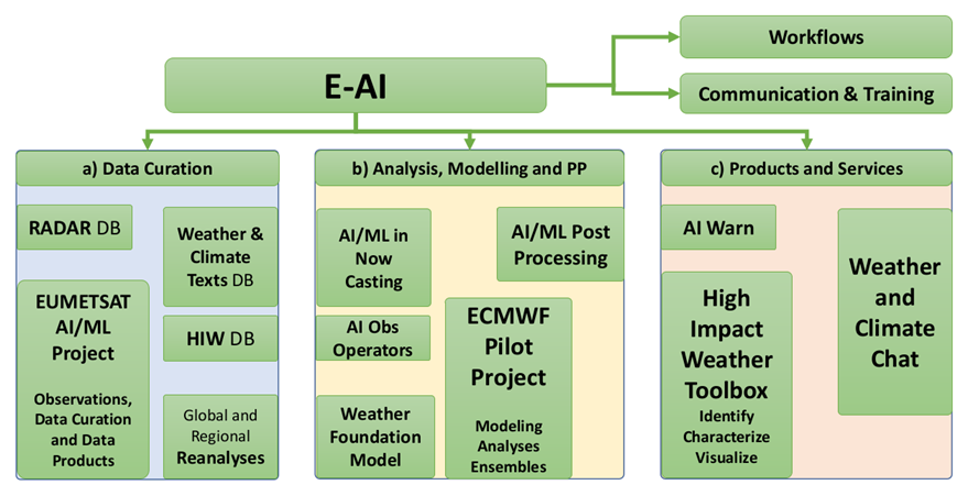
The E-AI programme will enhance the value of earth observations, gridded observational datasets, model fields and further datasets by making them AI-ready. The goal is to define and prepare a collection of datasets and develop appropriate interfaces and tools to make these data easily available for development, retraining, and operational use of AI/ML methods. Image sources: ESA (European Space Agency), EUMETSAT, DWD, Reinhardt et al. (https://doi.org/10.1175/AIES-D-22-0025.1) published under CC BY-SA 3.0 IGOData Curation
EUROCONTROL’s Network Manager (NM) is designated by Single European Sky (SES) legislation to manage the European airspace, linking together the elements of the European Air Traffic Management (ATM) system. Focusing on the performance of the European network, NM ensures that flights reach their destination safely, on time, with the least possible impact on the environment, and in a cost-efficient manner. EUMETNET regularly liaises with the Network Manager on a wide range of aviation meteorological topics, with the long-term goal of delivering a consistent network view of the weather conditions affecting the network at airport, regional and continental scales. This work requires proactive coordination between the European MET ANSPs and collaborative efforts with EUROCONTROL and the European Union Aviation Safety Agency (EASA) to work towards the vision of a better-connected Europe under the SES. EUMETNET’s Cooperation with EUROCONTROL
The eGAFOR forecast (eGAFOR Viewer) supports private pilots in central and south-eastern Europe with a uniform, harmonised, probabilistic, graphical, colour-coded Low-Level Forecast (LLF) for flights following visual flight rules. The service includes the assessment of the impact of the meteorological phenomena on flight routes. The MET ANSPs participating in eGAFOR are: - ARSO (Slovenia) eGAFOR
- BHANSA (Bosnia and Herzegovina)
- CCL (Croatia)
- HungaroMet (Hungary)
- ROMATSA (Romania)
- SHMÚ (Slovakia)
- SMATSA (Serbia and Montenegro)
- BULATSA (Bulgaria)
The CBCF is a collaborative forecast that provides EUROCONTROL’s Network Manager (NM), participating Air Navigation Service Providers (ANSPs), and other aviation stakeholders with strategic planning information about convective weather across European airspace. NM and the attached ATM-units use this information to coordinate with impacted Air Traffic Control Centres (ACCs) across Europe to minimise flight delays and improve aviation safety. The EUMETNET CBCF module comprises: - the operational framework to produce a collaborative weather chart CBCF participating MET ANSPsCross-Border Convection Forecast
- the organisational environment enabling the production and development of the forecast service in line with users’ requirements
- the designation of roles, responsibilities and interfaces amongst all stakeholders CBCF domain in 2025
The figure below shows the active GNSS stations currently providing data to E-GVap In E-GVap, we aim to densify the network of GNSS receivers, providing us with valuable ZTD data. Several EUMETNET members run global weather forecasting models; for that reason, data from outside Europe is also important. E-GVap Coverage
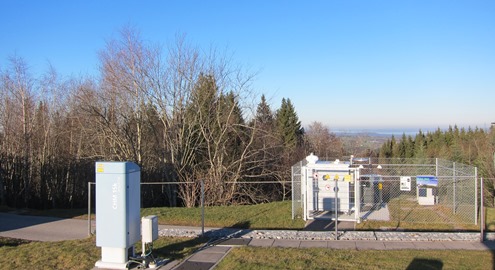
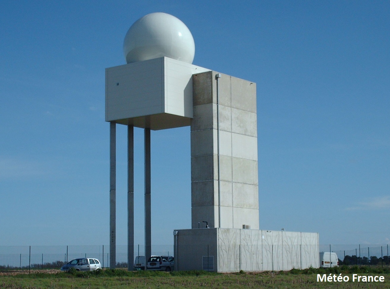
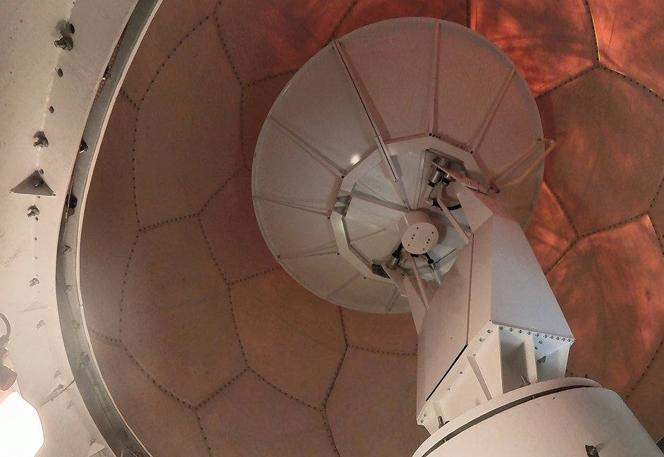
The aerosol and cloud network consists of more than 450 automatic lidars (light detection and ranging sensors) and ceilometers. The main purpose of the latter is to measure the height of the cloud base, which is important for planning safe navigation in aviation and understanding atmospheric stability and convection that can result in severe weather or favourable conditions for high-air-pollution episodes. The diverse applicability of ceilometer data explains the high density of the ceilometer network. The automatic lidars and ceilometers are centrally calibrated to create profiles showing how much light is scattered back by particles. That light is related to the size and concentration of particles in the atmosphere. Appropriate calibration techniques enable the estimation of the mass concentration of aerosols and their impact on the radiative transfer in the atmosphere. Ceilometer and automatic lidar at Hohenpeissenberg, Germany. Aerosol and Cloud Network
An interactive interface to analyse advanced aerosol properties can be found here: https://vprofiles.met.no/.
Data download (CEDA archive, registration required):
Aerosol and cloud profiler network
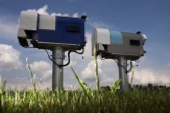
Microwave radiometers are passive instruments that measure the natural radiation from the atmosphere. These radiation measurements are presented as “brightness temperatures” in Kelvin units. We use the TROPOe software suite to convert the brightness temperatures into vertical profiles of temperature and humidity. These profiles typically cover the first 2 km of the atmosphere. Both brightness temperatures and profiles are disseminated via the Global Telecommunication System (GTS). In the future, they will also be disseminated via the WIGOS Information System (WIS). Microwave radiometers at Payerne, Switzerland. Temperature and Humidity Network
Between 2019 and 2023, the OPERA data centre (ODYSSEY) was gradually upgraded with three new production lines (CUMULUS/STRATUS, CIRRUS, and NIMBUS). The three new production lines are: • CUMULUS/STRATUS, a real-time data hub providing the incoming data to members in close to real-time for their own processing (e.g. production of regional composites or NWP assimilation) and to the other two production lines (CIRRUS and NIMBUS). This production line has been operational since mid-2021. – OPERA_Max Reflectivity_Product Sheet_Ed-2.0.pdf • NIMBUS produces the quality-controlled products centrally: instantaneous rain rate (mm/h) and 1-hour accumulation (mm) composites, wind profiles (expected in late 2025), and the quality-controlled volume data for NWP assimilation. It replaces the old ODYSSEY production for the above-mentioned products. The NIMBUS production has been operational since mid-2024. Documentation regarding the NIMBUS composites and their differences compared to the corresponding ODYSSEY can be found here: – NIMBUS_datasheet_composites_1.0_13062024.pdf OPERA support can be reached by email at support.opera[at]eumetnet.eu. Responses from the service desk are provided on a best-effort basis. Access to data The OPERA products are also available under license to Third parties: - For national meteorological services not participating in the OPERA programme that want to use the products for their official duties, contact info[at]eumetnet.euOPERA Data Production
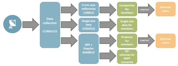 Figure: The schematic structure of the new OPERA data production.
• CIRRUS produces a 5-minute instantaneous maximum reflectivity composite (dBZ) for current weather, severe weather alerts and aviation needs. It replaced the old ODYSSEY maximum reflectivity composite with improved spatial (now with 1 km gridding) and temporal resolution (from 15 minutes to 5 minutes). The production has been operational since early 2024. Documentation on the CIRRUS maximum reflectivity product and its differences compared to the ODYSSEY maximum reflectivity product can be found here:
– OPERA5_Report_Cirrus-vs-Odyssey_Ed-2.0.pdf
– NIMBUS_composite_vs_ODYSSEY_1.0_19062024.pdf
EUMETNET members may use the composites for their official duties without a separate license. Their Numerical Weather Prediction (NWP) modelers obtain the quality-controlled volume data directly from the NIMBUS production line.
- For a research and education license, contact info[at]eumetnet.eu.
- For a license to exploit the OPERA products commercially, contact one of the EUMETNET members’ contact points (https://www.ecomet.eu/contact/members) or send an email to the EUMETNET Secretariat using the email address: info[at]eumetnet.eu
Over the year, the OPERA community has developed several software packages to exchange radar data from different sources and manufacturers. - ODIM version 2.41 (2024) OPERA Data Information Model (ODIM)
Data exchange in OPERA is currently conducted using files in the Hierarchical Data Format version 5 (HDF5), following the internally developed OPERA Data Information Model (ODIM). ODIM has been widely adopted and implemented both within and beyond the OPERA community, and it is continuously updated.
Software documentation:
- ODIM version 2.4 (2021)
- ODIM version 2.3 (2019)
- ODIM version 2.2 (2014)
- ODIM version 2.1
- ODIM version 2.01
Over the years, the OPERA community has produced an impressive library of documents, recommendations, and definitions. Many of the early technical documents are now more of historical value. Selected publications of OPERA 6 (2024 -2028) - Best practices for calibration and monitoring 25 October 2020 Selected publications of OPERA 4 (2013-2018) - OPERA the Radar Project, article in Atmosphere, 12 June 2019 (https://www.mdpi.com/478188) Selected Deliverables of OPERA 3 (2007-2012) - Status of use of polarimetric C and S band radars (2012) OPERA Publications
ODIM version 2.41 (2024 -for older versions, see software documentation)
Selected publications of OPERA 5 (2019-2023)
- ODIM version 2.4 (2021)
- OPERA-4: On the coexistence of weather radars and wind turbines, 25 February 2022
- Frequently asked questions about radars, 26 January 2016
- Best practices for calibration and monitoring 19 January 2019
- ODIM version 2.3 (9 January 2019)
- BUFR format and graphical format for polar volume data submitted to and composites produced by the OPERA, version dated 12 March 2012
- The Operational Weather Radar Network in Europe – article in Bull.Am.Met.Soc. 2014 (https://journals.ametsoc.org/view/journals/bams/95/6/bams-d-12-00216.1.xml)
- The Threat to Weather Radars by Wireless Technology – article in Bull.Am.Met.Soc. July 2016 (https://journals.ametsoc.org/view/journals/bams/97/7/bams-d-15-00048.1.xml)
- Maintenance keeps radars running – article in Bull.Am.Met.Soc. 2017 (https://journals.ametsoc.org/view/journals/bams/98/9/bams-d-16-0095.1.xml#:~:text=Most%20radars%20are%20equipped%20with,%2C%20the%20emergency%20power%20generator).
- Quality of the composites – report of a study
- Monitoring rain rates – report of a study
- Daily convective precipitation – report of a study
- Cost-benefit of dual-pol exchange – report of survey in 2016
- Improvement of rain rates using water phase (snow or rain) – report of a study
- Status of use of polarimetric X band radars (2012)
- Radar site selection and protection (2010)
- Impact study of radar observations by wind turbines (2010)
- Statement on wind turbines (2010)
- Statement of the OPERA group on processing RLAN interferences (2009)
- Recommendation on coexistence with 5 GHz RLAN (2008)
- Harmonised production practices for volume data, low-level reflectivity, and wind profiles (2008)
OPERA maintains a database of radar metadata provided by members. It is divided into active radars and archived information (radars no longer part of OPERA). Public information, location and details of the radars can be found here (Link: https://www.eumetnet.eu/wp-content/themes/aeron-child/observations-programme/current-activities/opera/database/OPERA_Database/index.html). OPERA Database
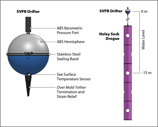
More than 150 E-SurfMar drifting buoys are permanently operating in the EUMETNET Composite Observing System (EUCOS) area. E-SurfMar relies on partner institutions in The Netherlands, Portugal, UK, France, Italy, Germany, Canada and the United States to deploy and maintain the drifting buoy network. Deployments are carried out using various vessels, including container ships, expedition sailboats, and racing yachts. Our goal is to optimise our networks for consistent spatial and temporal coverage. Drifting buoys, designed to track surface currents, have a hemispheric shape and include a holey sock drogue (sea anchor) at a standard depth of 15 metres below the surface. These buoys use GPS to measure their position and transmit surface air pressure and sea surface temperature data in real time via the Iridium satellite communication system. By analysing multiple reports from different positions, we can estimate near-surface ocean currents. The average operational lifespan of a drifting buoy is approximately 600 days. While sea surface temperature (SST) is important, we primarily focus on atmospheric surface pressure, as this parameter cannot be measured by satellites. A drifting buoy with the drogue (credit Lagrangian drifting laboratory) Drifting Buoys
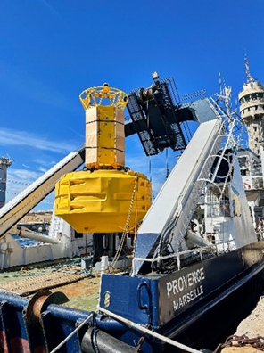
Moored buoys are anchored at fixed locations and regularly collect observations from various atmospheric and oceanographic sensors. These buoys measure a wide range of parameters crucial for operational applications, including both meteorological and oceanographic data. The meteorological parameters typically measured by moored buoys are air temperature, humidity, atmospheric pressure, and wind speed and direction. Oceanographic measurements generally include sea surface temperature and, in some cases, ocean currents and salinity. Sea state (the general condition of the ocean surface with respect to wind waves and swell at a specific location and time), is also of significant interest for many applications. Wave parameters are measured by tracking the buoy's displacement, assuming it responds to waves without affecting the measurement. Modern moored buoys transmit wave parameters and spectral data through the Global Telecommunication System (GTS). The quality of the data from these buoys is considered amongst the finest available from surface marine stations. These measurements are vital for weather forecasting, maritime safety and scientific research, whilst also serving as crucial reference points for calibrating and verifying satellite measurements and numerical atmospheric and ocean models. Moored buoys can be fitted with additional sensors to meet specific research or operational requirements. Some are capable of measuring parameters throughout the water column, which is the vertical section of water from surface to seabed. This provides valuable data on subsurface conditions at various depths, offering a comprehensive view of oceanic processes from top to bottom. Moored Buoys
Voluntary Observing Ships (VOS) are a vital part of the global weather observation system, providing essential meteorological and oceanographic observations at sea. Weather stations managed by National Meteorological Services and installed on board VOS typically record and transmit data on surface wind speed and direction, air temperature, humidity, sea surface temperature (SST), atmospheric sea level pressure (SLP), cloud characteristics, visibility, wave and swell parameters, and overall present weather status. The VOS data are crucial for real-time weather forecasting and historical climate studies, especially in data-sparse regions like the Arctic. They contribute significantly to our understanding of atmosphere-ocean interactions, which is essential for addressing global warming and improving long-range weather forecasts. There are two main types of VOS: conventional VOS, where sailors make observations and record data in meteorological logbooks, and VOS with automated systems that use electronic logbooks for streamlined reporting. The NMS of the Netherlands (KNMI) has developed the Turbowin software package to enhance data acquisition, quality and quantity from conventional VOS. EUCAWS station on a ferry New Mini-EUCAWS logger Observing Ships
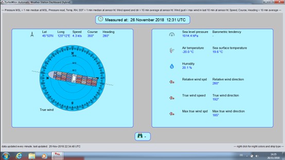 Turbowin+ software
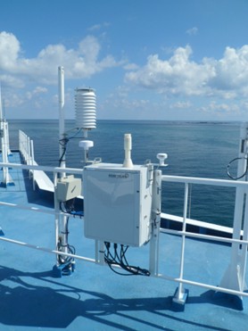
The number of VOS with automated weather stations (AWS) has increased, resulting in more frequent marine observations, usually with hourly transmissions. In 2024, more than 265 operational AWS units have reported data on the Global Telecommunication System (GTS) from ships recruited by several NMSs. A common AWS, called EUCAWS, was developed in 2017 under E-SurfMar and has been installed by national meteorological services on several VOS since then.
In 2022-2023, E-SurfMar developed a new mini automatic weather station for installation on board vessels. This mini station offers a wide range of possibilities for connecting sensors and sending messages. Power consumption is low, installation is easy, and its cost is low. This station is now operational and about ten have already been installed on European vessels.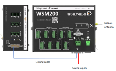
The E-AI programme is structured in three modules: a) Data Curation, b) Analysis, Modelling and Post-Processing, and c) Products and Services. By working together on overarching Workflows, AI/ML can be used effectively across the entire value chain while also addressing necessary technical, administrative, and structural requirements. Moreover, the programme offers Communication and Training opportunities to ensure an efficient flow of information on AI/ML developments within and beyond the E-AI programme.Structure of the E-AI Programme
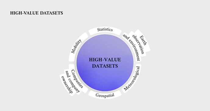
In the Implementing Regulation of the revised Open Data Directive, the European Union has defined a set of High-Value Datasets (HVDs). These are data that have high value for the community. One of the sets defined by the Regulation concerns meteorological data: weather observations, climate time series, warnings, weather radar data and numerical weather prediction (NWP) data. Following the regulation, these data should be available free of charge, under an open license, in a machine-readable format using Application Programming Interface (API), and bulk downloadable. Further information on EUMETNET’s response to the High-Value Datasets Regulation can be found under the RODEO page. High-Value Datasets
MeteoGate Community components are needed to deliver shared capabilities, e.g. a data catalogue or access management. They will be established and operated by EUMETNET or its members and useable by data publishers and consumers inside and outside the hydro-meteorological community. 1- A shared Data Catalogue defining and describing data assets and data collections, indexed, linked, and searchable to support data discovery and usage. 2- A Message Broker with a subscription service for notifications about the updates to both discovery metadata and the data. 3- Identity & Access management to control user and system access to platforms and platform services. 4- API management providing the interface between data consumers and underlying data stores, enabling managed access and usage of data and data products. 5- An Insights service reporting on data discovery and publication transactions for Data Publishers to derive management information. MeteoGate Community Components
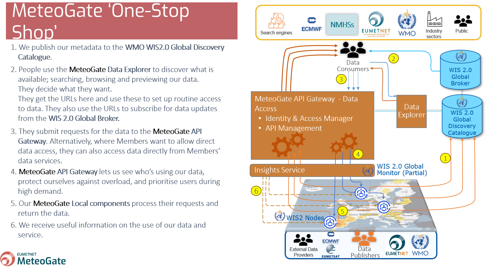
1- MeteoGate will enable the sharing of hydrological and meteorological data holdings both within the European Meteorological Infrastructure (EMI) and between the EMI and external stakeholders (global WMO community, public and private sector bodies, research institutions, citizens, etc.). The MeteoGate System will be part of the WMO Information System and will implement the WIS 2.0 principles. 2- The initial scope of MeteoGate includes sharing the following categories of data: Core Data (WMO Unified Data Policy), Meteorological High-Value Data (EU Regulation 2019/1024), and Data for Official Duty1. The MeteoGate System will be extensible so that additional functions can be incorporated as user requirements emerge. 3- MeteoGate will enable data sharing in a manner that is compliant with national and international legislation, regulation, and policy commonly applicable to the EMI, with priority given to obligatory requirements. 4- MeteoGate will support the data-sharing policies commonly used within the EMI, including but not limited to free and open data exchange. 5- MeteoGate will neither affect ownership of shared data holdings nor impose additional conditions on data sharing. 6- The ownership, origin and license / usage terms of data holdings shared via MeteoGate will be visible to all stakeholders. 7- Policies and technical standards ensuring interoperability and consistency of operation among components of the MeteoGate will be mutually agreed and maintained by European NMHSs, EUMETSAT and ECMWF under the auspices of EUMETNET. 8- MeteoGate will be comprised of multiple components (e.g. data sharing platforms and systems), each owned and operated by constituents of the EMI and conforming with the mutually agreed policies and technical standards. Providers of MeteoGate components are encouraged to develop and/or operate them in a manner that supports the community. MeteoGate components may form part of national data-sharing infrastructures and vice versa. 9- MeteoGate will build upon existing data-sharing infrastructures, incorporating them when they conform to the mutually agreed policies and standards. MeteoGate will undergo continuous development as needs arise in the EMI. 10- MeteoGate will provide access to data holdings in-situ where local capability exists to do so. Moving data to a remote system only to support data sharing should be avoided. 11- MeteoGate will have a single catalogue describing all its data holdings and will provide mechanisms to enable users to search for the data they need. MeteoGate will make metadata contribution to the catalogue easy; aiming to avoid duplicate effort where data providers contribute to multiple data sharing initiatives. MeteoGate Principles
Data Publishers such as National Meteorological Services (NMSs) will need to create and operate (potentially in collaboration) several MeteoGate Local components to exploit the system’s benefits. They can choose the level of maturity of the solutions they want to implement – from manual to fully automated. There are collaborative options that allow the reduction of the costs of developing Local components; most of them are needed for NMSs’ obligations towards WMO and its WIS2.0. - Persistence to store and allow for shared data to be accessed through APIs Data Publishers and MeteoGate Local Components

- Data Processing in line with WMO regulations and MeteoGate Policies, Standards and Processes (PSPs) to standardise and productise data so that it can be shared using APIs
- Local Broker to send change notifications to the WMO Global Broker of news and updates to discovery metadata and shared data
- Metadata Management to create, publish and maintain the discovery and provenance metadata to share changes with the Global Discovery Catalogue.
- Data Access to expose data to MeteoGate users using interactive APIs through the API Gateway
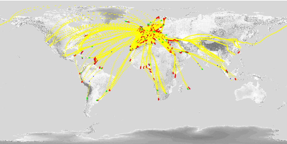
The coverage for the EUMETNET AMDAR network for a typical day is shown on the map below. Yellow plots indicate observations taken en-route with red and green plots representing aircraft ascent and descent profiles. EUMETNET AMDAR Coverage
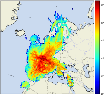
The coverage for the EUMETNET-derived data network from the European Meteorological Aircraft Derived Data Centre for a typical day is shown on the map below. This shows how tens of millions of observations are collected daily, with the highest concentrations indicated by the red colours.Aircraft-derived Data Coverage
 Total Coverage
Number of derived obs in [0.5x0.5]° - 15/01/2025
AutoPollen programme participants come from 25 institutes and associations from 22 countries that are either EUMETNET members or cooperating third parties. An extensive list of participants, as well as a list of publications and links to projects and networks across Europe, can be found on the AutoPollen website along with relevant data. Furthermore, the AutoPollen programme collaborates with several European-level projects and organisations, including: Horizon Europe Project SYLVA (A SYstem for ReaL-Time ObserVation of Aeroallergens), Copernicus Atmospheric Monitoring Services (CAMS), the COST Action ADOPT (New Approaches in Detection of Pathogens and Aeroallergens – CA18226), EURAMET on the BioAirMet project, and Working Group 39 of the European Normalisation Committee (CEN - Technical Committee 264). Participants and Collaborations
The E-GVap programme exemplifies the synergy between geodesy and meteorology. Through partnerships with geodetic organisations such as EUREF (the Reference Frame Sub-Commission for Europe of the International Association of Geodesy (IAG)), EUPOS (European Position Determination System) , and EPOS (European Plate Observing System), EUMETNET has access to crucial GNSS data. Geodesists primarily use GNSS receivers for precise positioning and view atmospheric delay—particularly from water vapour—as “noise” to be eliminated. In contrast, meteorologists recognize this "noise" as valuable information about atmospheric water vapour content. Zenith Total Delay (ZTD) estimates provided by geodetic institutions play a key role in improving positioning accuracy. This atmospheric delay, which geodesists seek to remove, contains data that is essential for some meteorological applications. This collaboration allows both fields to benefit, advancing their respective goals while contributing to a broader understanding of atmospheric processes. The participating GNSS analysis centres are: - AUT Aristotle University of Thessaloniki, Greece Participating GNSS Analysis Centers
- ASI e-geos/Telespazio, Italy
- BKG Federal Agency for Cartography and geodesy
- BMEG Budapest University of Technology and Economics, Hungary
- CONH UCAR, USA
- GA01 Geoscience, Australia
- GFZ Helmholtz Centre Potsdam, GFZ German Research Center for Geosciences
- GOPE Geodetic Observatory Pecny, Czech Republic
- IGE Instituto Geografica National, Spain
- IMO Icelandic Met Office, Iceland
- KNMI Royal Meteorological Institute of the Netherlands
- LPT SwissTope, Switzerland
- METO UK Met Office
- NGA Lantmateriet (Swedish Mapping, Cadestre and Land Regi. Authority), Sweden
- ROB Royal Observatory of Belgium
- SGN Institut Geographique National, France
- SGOB Satellite Geodetic Observatory, IGCRS + Technical Univ. Budapest, Hungary
- TUWN Technical University Vienna, Austria
- UL01 Univ. of Luxembourg, Faculty of Science and Communication, Luxembourg
- WLIT Lithuania, set up and run by WUEL
- WTWN Taiwan, set up and run by WUEL
- WUEL Wroclaw University + Institute of Geodesy and Geoinformatics, Poland
- WUHN GNSS research Center, Wuhan University, China
E-Profile's wind network consists of about 30 radar wind profilers, about 100 weather radars providing wind profiles and new Doppler lidars. All radars send processed vertical wind profile data to E-Profile. According to the operating frequency of the radar, the derived wind profiles cover the atmospheric boundary layer (up to about 3 km), full troposphere (up to about 12 km), or troposphere and lower stratosphere (up to about 20 km). Lidar data are processed centrally using the Doppler lidar toolbox developed by the National Meteorological Service of Germany (DWD). The range of the Doppler lidars depends on the presence of aerosols and is typically limited to the atmospheric boundary layer. Data download (CEDA archive, registration required): Wind Network
E-Profile maintains a list of recommended stations for data assimilation into numerical weather prediction models based on the EUCOS (EUMETNET Composite Observing System) monitoring results and considering data quality and timeliness.
Please contact e-profile[at]meteoswiss.ch to get the current list of the E-Profile stations. Wind profiler at Lindenberg, Germany.
Wind profiler network
Between 2019 and 2023, the OPERA data centre (ODYSSEY) was gradually upgraded with three new production lines (CUMULUS/STRATUS, CIRRUS, and NIMBUS). The three new production lines are: • CUMULUS/STRATUS, a real-time data hub providing the incoming data to members in close to real-time for their own processing (e.g. production of regional composites or NWP assimilation) and to the other two production lines (CIRRUS and NIMBUS). This production line has been operational since mid-2021. – OPERA_Max Reflectivity_Product Sheet_Ed-2.0.pdf • NIMBUS produces the quality-controlled products centrally: instantaneous rain rate (mm/h) and 1-hour accumulation (mm) composites, wind profiles (expected in late 2025), and the quality-controlled volume data for NWP assimilation. It replaces the old ODYSSEY production for the above-mentioned products. The NIMBUS production has been operational since mid-2024. Documentation regarding the NIMBUS composites and their differences compared to the corresponding ODYSSEY can be found here: – NIMBUS_datasheet_composites_1.0_13062024.pdf OPERA support can be reached by email at support.opera[at]eumetnet.eu. Responses from the service desk are provided on a best-effort basis. Access to data The OPERA products are also available under license to Third parties: - For national meteorological services not participating in the OPERA programme that want to use the products for their official duties, contact info[at]eumetnet.euOPERA Data Production
Figure: The schematic structure of the new OPERA data production.
• CIRRUS produces a 5-minute instantaneous maximum reflectivity composite (dBZ) for current weather, severe weather alerts and aviation needs. It replaced the old ODYSSEY maximum reflectivity composite with improved spatial (now with 1 km gridding) and temporal resolution (from 15 minutes to 5 minutes). The production has been operational since early 2024. Documentation on the CIRRUS maximum reflectivity product and its differences compared to the ODYSSEY maximum reflectivity product can be found here:
– OPERA5_Report_Cirrus-vs-Odyssey_Ed-2.0.pdf
– NIMBUS_composite_vs_ODYSSEY_1.0_19062024.pdf
EUMETNET members may use the composites for their official duties without a separate license. Their Numerical Weather Prediction (NWP) modelers obtain the quality-controlled volume data directly from the NIMBUS production line.
- For a research and education license, contact info[at]eumetnet.eu.
- For a license to exploit the OPERA products commercially, contact one of the EUMETNET members’ contact points (https://www.ecomet.eu/contact/members) or send an email to the EUMETNET Secretariat using the email address: info[at]eumetnet.eu
Meteo-France has developed a set of quality control tools to monitor the status of the E-SurfMar observation networks: https://esurfmar.meteo.fr/qctools/. Primarily based on comparisons of observations with model results, these tools may be used to monitor any surface marine observation platform in the world that reports data onto the GTS.Every month, the performances of the networks in matters of data availability, timeliness, and quality are assessed and compared to previous months and targets. Monitoring
Over the years, the OPERA community has produced an impressive library of documents, recommendations, and definitions. Many of the early technical documents are now more of historical value. Selected publications of OPERA 6 (2024 -2028) - Best practices for calibration and monitoring 25 October 2020 Selected publications of OPERA 4 (2013-2018) - OPERA the Radar Project, article in Atmosphere, 12 June 2019 Selected Deliverables of OPERA 3 (2007-2012) - Status of use of polarimetric C and S band radars (2012) OPERA publications
- ODIM version 2.41 (2024 -for older versions, see software documentation)
Selected publications of OPERA 5 (2019-2023)
- ODIM version 2.4 (2021)
- OPERA-4: On the coexistence of weather radars and wind turbines, 25 February 2022
- Frequently asked questions about radars, 26 January 2016
- Best practices for calibration and monitoring 19 January 2019
- ODIM version 2.3 (9 January 2019)
- BUFR format and graphical format for polar volume data submitted to and composites produced by the OPERA, version dated 12 March 2012
- The Operational Weather Radar Network in Europe – article in Bull.Am.Met.Soc. 2014
- The Threat to Weather Radars by Wireless Technology – article in Bull.Am.Met.Soc. July 2016
- Maintenance keeps radars running – article in Bull.Am.Met.Soc. 2017
- Quality of the composites– report of a study
- Monitoring rain rates – report of a study
- Daily convective precipitation – report of a study
- Cost-benefit of dual-pole exchange – report of survey in 2016
- Improvement of rain rates using water phase (snow or rain)– report of a study
- Status of use of polarimetric X band radars (2012)
- Radar site selection and protection(2010)
- Impact study of radar observations by wind turbines (2010)
- Statement on wind turbines (2010)
- Statement of the OPERA group on processing RLAN interferences (2009)
- Recommendation on coexistence with 5 GHz RLAN(2008)
- Harmonised production practices for volume data, low-level reflectivity, and wind profiles (2008)
Over the years, the OPERA community has developed several software packages to exchange radar data from different sources and manufacturers. Software documentation: - ODIM version 2.41 (2024) HDF5 The ODIM H5 exchange software ODIM H5 Example file of ODIM 2.4: T_PAZA41_C_LPMG_20241205100002.h5.zip BUFR The legacy format, BUFR, is no longer used or maintained in OPERA, but the software for encoding and decoding is still provided below. The encoder includes a pre-processor that prepares an ASCII file as input for the final processor, which then writes the binary table. BUFR software and tables to download: - BUFR exchange software BUFR 3.2 - BUFR 3.2 binary software for Windows - BUFR 3.2 binary software for LINUX - BUFR tables (Nov 19,2012) BUFR local tables and BUFR WMO tables - BUFR mf Tooling to write ODIM volume data using HDF or BUFR and a validator/converter for these data representation written in C Documentation: - OPERA BUFR guidelines (2003) - Release Notes for the BUFR 3.2 - Description of the BUFR software - Description of the BUFR software “programmers API” - Primer on the use of the BUFR tables OPERA Data Information Model (ODIM)
Data exchange in OPERA is currently conducted using files in the Hierarchical Data Format version 5 (HDF5), following the internally developed OPERA Data Information Model (ODIM). ODIM has been widely adopted and implemented both within and beyond the OPERA community, and it is continuously updated.
- ODIM version 2.4 (2021)
- ODIM version 2.3 (2019)
- ODIM version 2.2 (2014)
- ODIM version 2.1
- ODIM version 2.01
Quality monitoring in weather observations is crucial for maintaining the integrity and reliability of meteorological data. It plays a vital role in ensuring that forecasts, climate studies, and other meteorological applications are based on accurate and dependable information. Quality Monitoring
We develop and operate tools to monitor, assess and report on the performance of observation instruments and systems used by EUMETNET Members. We implement robust quality control processes to detect and address potential errors or inconsistencies in the data, thereby improving the overall accuracy of weather predictions and climate assessments. Performance is measured against internationally agreed standards, and we collaborate with EUMETNET Members to resolve issues and share knowledge.
Our quality monitoring tools are also used to promptly identify and resolve instrument malfunctions or calibration issues, ensuring the continuous availability of high-quality data for stakeholders in the meteorological community.
This commitment to quality not only enhances the credibility of weather services but also supports critical decision-making processes in sectors such as aviation, agriculture, and disaster management, where precise weather information is essential for safety and operational efficiency.
2019 2020 2021 2023 2024 Publications
Jonathan Demaeyer and Stéphane Vannitsem: Correcting for model changes in statistical postprocessing – an approach based on response theory, Nonlin. Processes Geophys., 27, 307–327, https://doi.org/10.5194/npg-27-307-2020, 2020.
Stéphane Vannitsem and Jonathan Demaeyer: Statistical postprocessing of ECMWF forecasts at the Belgian met service, ECMWF Newsletter No. 164, 4–5, 2020.
Jonathan Demaeyer, Stéphane Vannitsem and Bert Van Schaeybroeck: Statistical postprocessing of ensemble forecasts at the Belgian met service, ECMWF Newsletter No. 166, 21–25, 2021, doi: http://dx.doi.org/10.21957/vb78ui92dj.
Stéphane Vannitsem , John Bjørnar Bremnes; Jonathan Demaeyer, Gavin R. Evans, Jonathan Flowerdew, Stephan Hemri, Sebastian Lerch, Nigel Roberts, Susanne Theis, Aitor Atencia, Zied Ben Bouallègue, Jonas Bhend, Markus Dabernig, Lesley De Cruz, Leila Hieta, Olivier Mestre, Lionel Moret, Iris Odak Plenković, Maurice Schmeits, Maxime Taillardat, Joris Van den Bergh, Bert Van Schaeybroeck, Kirien Whan and Jussi Ylhaisi: Statistical Postprocessing for Weather Forecasts – Review, Challenges and Avenues in a Big Data World. Bull. Amer. Meteor. Soc., doi: https://doi.org/10.1175/BAMS-D-19-0308.1.
Demaeyer, J., Bhend, J., Lerch, S., Primo, C., Van Schaeybroeck, B., Atencia, A., Ben Bouallègue, Z., Chen, J., Dabernig, M., Evans, G., Faganeli Pucer, J., Hooper, B., Horat, N., Jobst, D., Merše, J., Mlakar, P., Möller, A., Mestre, O., Taillardat, M., and Vannitsem, S. The EUPPBench postprocessing benchmark dataset v1.0, Earth Syst. Sci. Data, 15, 2635–2653, https://doi.org/10.5194/essd-15-2635-2023, 2023.
Primo C., Ben Bouallègue Z., Bhend J., Lerch S., Van Schaeybroeck B., Demaeyer J., EUPPBench: A forecast dataset to benchmark statistical postprocessing methods, ECMWF Newsletter No. 179, 2024.