EUMeTrain
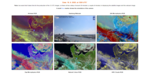
EUMeTrain has recently finalised the first phase of a project combining satellite imagery and webcam images from specific locations around Europe.
The project was of interest to the members for practical reasons: using the data in weather briefings or having a quick view of the situation over different regions and countries, etc. Currently, the webcams show the sky over two cities (Vienna and Hamburg). They present a useful learning tool and are a good means for understanding and comparing the type of clouds seen from the ground with the corresponding RGB colours in satellite imagery.
The project is currently in its infancy and it is still developing. The plan for the future is to add more webcams from cities around Europe, to get a better picture of the weather, and to add more times during the day, currently there is only one image at 12:00 UTC.
Check out the website.

